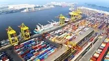
Iran to prepare new maritime maps of Persian Gulf
A member of the board of directors of Iran’s Ports and Maritime Organization (PMO) said Iran has undertaken to provide new maritime maps of the Persian Gulf.
MEHR: A member of the board of directors of Iran’s Ports and Maritime Organization (PMO) said Iran has undertaken to provide new maritime maps of the Persian Gulf.
Upon the announcement of the Regional Organization for the Protection of the Marine Environment (ROPME) Sea Area Hydrographic Commission (RSAHC) and the International Hydrographic Organization (IHO), Iran has been tasked with providing the maritime maps of the Persian Gulf, Sea of Oman and a part of the Indian Ocean, Majid Ali Nazi stated.
According to the road map of the International Hydrographic Organization, the new standards of the S-100 series will replace the old standards for the production of the navigational map by 2026, he added.
He noted that the navigational maps based on the standard of the S-100 series will provide the sailors with all types of necessary data, including meteorological information, waves, currents, and seabed views.
ROPME Sea Area Hydrographic Commission (RSAHC) is one of the fifteen regional commissions of the International Hydrographic Organization throughout the world founded to establish coordination between the member states for the realization of predefined goals and programs related to hydrographic data collection and the production and publication of navigational charts as proposed by Iran in 2000.